Wednesday, March 26, 2014

Doin' The Wave

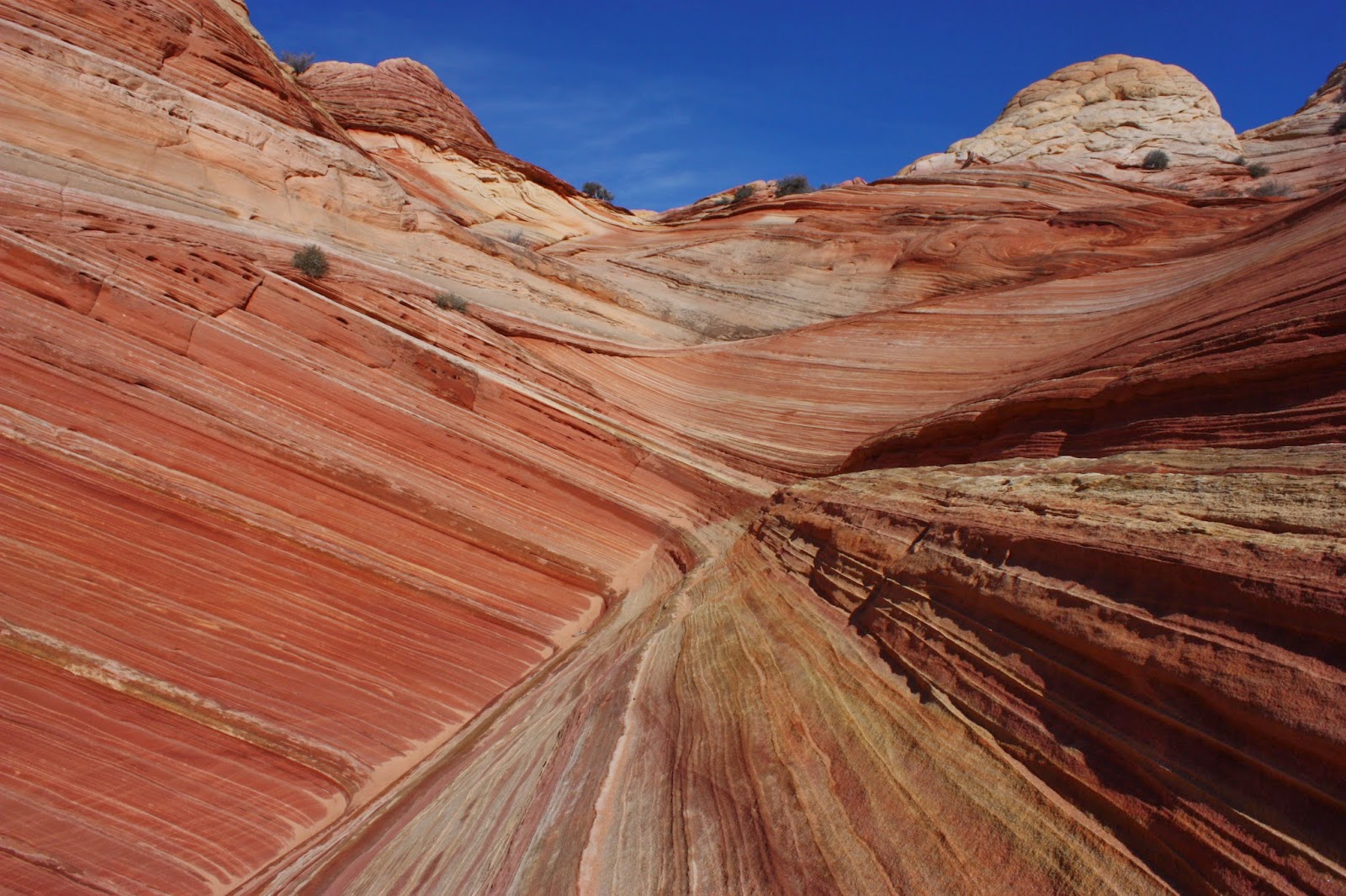
By far, the most popular and recognizable area within the Vermillion Cliffs National Monument and its surrounding areas is a place simply known as "The Wave." The first time you see photos of this area, it's immediately obvious why people travel from across the world to visit the incredible geologic formations of red, white, and yellow swirling slickrock. 

However, visiting The Wave is not done easily. Due to its popularity, and the fragile nature of the sandstone (which visitors hike directly upon) the Bureau of Land Management requires visitors to obtain permits in advance. 20 permits are issued for each day - 10 of these are issued online several weeks in advance, and the other 10 are set aside as "walk-in" permits issued the day before your desired trip. All of the permits are issued based on a lottery system, rather than "first come, first serve," so obtaining a permit is simply the luck of the draw. For more information, refer to the BLM's website HERE.


To give you an idea of the likelihood of obtaining a Wave permit, especially if your dates aren't flexible: it took me 4 or 5 attempts to obtain a walk-in permit before I finally succeeded, and these attempts were all during the "slow" season. During the summer months, your odds decrease significantly. Luckily for me, I lived in Kanab (where they do the walk-in lottery) so I didn't have a high sense of urgency to obtain a permit during a specific day.

For those who are unable to obtain a Wave permits: DO NOT BE DISCOURAGED! The Wave is just one of many options you have to explore in the area. Don't let its popularity fool you, there is other stuff that is just as good, if not better than The Wave. Ask a ranger in the Kanab BLM visitor center and they'll be more than happy to direct you to a viable alternative to The Wave.

One more important point I'd like to make before describing my hike to The Wave - for those lucky enough to obtain a permit: This is not your "average" 5.5 mile hike. Most of the hike is off trail, with little to no shade. The BLM will hand out a trail guide with pictures of landmarks to help guide you along the way. Make sure you bring this on your hike. Without it, even the most advanced hikers could lose their way, especially if it's their first time to The Wave. Bring plenty of water, especially in the summer - more than you think you'll need. Most importantly, don't do anything that you feel is beyond your comfort/ability level. Normally, I'm not one to try and scare people away, but last July (2013) alone, 3 hikers died while attempting The Wave, and all cases were completely avoidable had they been better prepared, and had a better idea of their abilities.

Thanks for listening to my shpeel. Now, on to the fun stuff!

I was pretty excited when I finally scored a Wave permit, especially after one of my failed attempts when the odds were considerably in my favor (14 people for 10 permits) and Stephany and I were 2 of the 4 left out. Ouch.

The Wave shares a trailhead with Wire Pass up the House Rock Valley Road, but the trail splits out of the wash, where there is an obvious sign. Make sure you have a permit!
For a while, there is an obvious trail, but soon, you begin hiking across slickrock with no trail or rock cairns to guide you. I can't over-empasize how helpful the BLM's handout is in helping you find your way. 

We chose a sunny but chilly December day (in 2011) to complete the hike. Overall, the hiking weather was perfect, and it's nice not having to worry about the blistering summer heat. If at all possible, I highly recommend hiking The Wave during the "slow season."

Despite all of my warnings about preparing to hike The Wave, if you're an advanced hiker, chances are you won't find the hike to be overly difficult. It's truly amongst the most fascinating marvels that nature has to offer. 

During my hike, I didn't take many photos along the way, but once I arrived at The Wave, I had a tough time putting my camera down. 


Warning: tons of pics to follow!


(Yes, dogs are allowed at The Wave!)


Doing The Wave Dance!


(Actually, it's my dance for all things awesome.)


We scrambled up to a high point to catch some views of the surrounding area.


Obviously, a trip to The Wave is about way more than The Wave itself.

Back to the streaky stuff!


Perhaps my personal favorite:


Wave Cave (or cavern, or whatever...)


Making our way back:


Sorry if that photo overload was a bit excessive, but I think it was necessary!

Continuing back to the trailhead left us with a feeling of complete satisfaction. One day I hope to return to The Wave but if I don't, it's okay, because I know I'll never forget it. 

If you are fortunate enough to get a Wave permit, I am sure you will be thoroughly satisfied with your experience, as I was. If you are unable to obtain one: I can almost guarantee that you will also be thoroughly satisfied by one of the countless other options the area has to offer.

Wednesday, March 12, 2014

Wire Pass and Buckskin Gulch

Within the Vermillion Cliffs Wilderness area lies Paria Canyon and its tributaries. One of its main tributaries is Buckskin Gulch, which is arguably the longest slot canyon in the world at 21 miles, and is certainly one of the most impressive.

There are several different ways to approach Buckskin Gulch, and can be done as a backpacking trip with a one-way shuttle. If interested in doing Buckskin Gulch as a backpacking trip, you can find more information HERE.

As a day hike, the most popular route starts at the Wire Pass trailhead, where there is an obvious parking area 8 miles up the House Rock Valley Road, south of highway 89 (between Kanab, Utah and Page, Arizona.) This dirt road is usually in decent shape, but may be impassable when wet.

At first, the hike starts up a wash and is pretty uneventful, but know that it gets much, much better!

Soon, you enter Wire Pass, a tributary of Buckskin Gulch and an impressive slot in its own right. I have taken two trips into Buckskin Gulch via Wire Pass. Here are the highlights.

Stephany, who had just moved to Kanab from Connecticut a couple of months prior:
(Apparently, they don't have slot canyons like this back east.)


After about 1.7 miles, Wire Pass joins Buckskin Gulch, where the canyon opens up in spectacular fashion, with towering, streaked rock walls all around. 

Here's a photo at the confluence, looking back towards Wire Pass:


For scale:
Once reaching Buckskin Gulch you can either take a left and head back towards the House Rock Valley, or a right, and wander for miles. Buckskin Gulch's canyon walls are much higher than Wire Pass, but not as narrow in most sections. I definitely recommend hiking to Buckskin via Wire Pass rather than starting on Buckskin from the beginning. Wire Pass offers a slightly different, more "intimate" slot canyon experience.

Here's a look into Buckskin Gulch (right of the confluence from Wire Pass):
Working our way back through Wire Pass, which sometimes opens up with views of colorful slickrock:


On a different trip, I took my friend Shenon on the same hike while he visited me in Kanab. This time, I elected to go left at the confluence. We discovered some interesting mud slabs that we entertained ourselves with. 


Soon, we reached an area where the canyon opened up, and we were able to hike up the slickrock and explore the area a bit more. 

In some areas, the rock formations resemble the nearby Wave.


After a while, we decided to sit back, relax, and soak in the views.


On our way back through Buckskin Gulch, we spotted a Gopher Snake. Surprising, considering it was a chilly November day. 
Wire Pass and Buckskin Gulch are spectacular, easily accessible slot canyons that offer the versatility of short day hikes or longer, overnight adventures. Nearby, there are countless other attractions that are also worth exploring. As I recollect these trips, it makes me miss slot canyon and slickrock country. Trust me, if you get the chance, you don't want to miss out on exploring these amazing places!

Monday, February 10, 2014

Kanab Utah Introduction

Kanab, Utah is located in the extreme southern part of the state, only a few miles from the Arizona border, and about 1.5 hours (driving time) east of St. George. From December, 2010 until April, 2013, I called Kanab home (with the exception being the summer of 2011 when I was in Alaska.)

Kanab is about as much of an "epicenter" as it gets for outdoor recreation. Zion National Park, Bryce Canyon National Park, Dixie National Forest, Cedar Breaks National Monument, Grand Staircase-Escalante National Monument, Vermillion Cliffs National Monument, Glen Canyon National Recreation Area, Kaibab National Forest, and the north rim of Grand Canyon are all within a hop, skip, and a jump of Kanab. Some of these areas offer year-round and (mostly) snow-free recreation, which only adds to Kanab's appeal.

I was lucky enough to explore many of the areas listed above during my time in Kanab. Some of these were well-known and frequently visited, but others were remote and isolated (requiring high-clearance 4-wheel drive vehicles to access.) It's always best to err on the side of caution when headed out into remote areas, but the well-prepared shouldn't be dissuaded from exploring some of the most spectacular and unique places in the world. I always find "harder to reach" places that much more rewarding when I get there.

Many of these areas that I'll describe you can find on the free map of the Grand Staircase-Escalante National Monument, which you can pick up at an area visitor center or download HERE.

I hope you enjoy my adventures from the Kanab area!

Thursday, February 6, 2014

Wintery Zion and Eagle Crags

Last January (2013) while living in Kanab, Utah, I had a free day to just get out and explore. The options were plentiful, but it had been a while since taking a Zion trip. I decided it would be wise to go check out Zion's low elevation southwestern end, since the recent cold, snowy conditions had probably left many of the Park's trails very slick and icy. 

I drove through the Park's eastern entrance, through the tunnel, and down the windy road that drops down towards the canyon floor. At one of the road's bends, I stopped at a pullout and took an unmarked trail that followed a frozen creek. Up ahead, I noticed some impressive icicles draping off the rock face.

Frozen river with icicles in the background:


The closer I got to the icicles, the more impressed I became.


 I didn't dare get much closer than this:


Although probably pretty common, the icicles were a first time Zion observation for me. I stood around in awe for quite a while before retracing my steps (only about a hundred yards) to my car.

Another look at the creek:


I hopped back in the car, impressed with my unexpected discovery and continued towards the southwest entrance. 


After studying my Zion area map, I decided to head out the Eagle Crags trail, just south of the town of Rockville on BLM land. "Eagle Crags" refers to the obvious rock formations in this area. I did no research and knew very little about the trail, but why not check it out?

The road accessing the trailhead was pretty rough, and probably should only be attempted by high clearance vehicles, preferably with 4-wheel drive. My Xterra didn't have much trouble, but I took it pretty slowly. For further directions to the trailhead, click HERE

When I reached the trailhead, the Crags were looming large to the south.


The trail begins fairly flat before rising towards Eagle Crags and into the Canaan Mountain Wilderness. 

The views along the way were awesome, and offered glimpses to the east towards Zion's seldom visited Parunuweap Canyon (East Fork of the Virgin River.)

Parunuweap is the Canyon directly beyond the pond in this photo, between Johnson Mountain (left) and Shunesburg Mountain (right): 


Another view, panning to the left:


As the trail ascended towards the Eagle Crags, it became progressively snow-covered, until I eventually reached an area where only one other person had been up there since the last storm. 

I followed their boot prints until I was directly beneath the Crags.


I finally reached the area where the prints I had been following stopped, stepped off for a view, and turned around. This was also where the obvious trail ended, but I wasn't quite ready to turn around. 

I continued trudging across the now unbroken snow until I was pretty much bushwhacking through junipers and scrambling across rocks. In the distance I could see some rugged peaks deep in the heart of Canaan Mountain. Apparently there's a way to navigate from Eagle Crags to or from Water Canyon near Colorado City, Arizona. I decided on a stopping point and scouted out the terrain. It seems like that would be a gnarly navigation, but a challenge I'd be open to attempting. 

Here's my photo of the rugged peaks in the distance (sorry for the poor quality, the glare was pretty bad.)

I retraced my steps quickly, as I didn't want to run out of daylight, but I made a point to turn around and get one last glimpse of the Eagle Crags.


While driving back home, I decided to take the "scenic route" across Smithsonian Butte, which runs 9 miles from Grafton to Colorado City. This is a dirt road that was pretty rough in a few areas, but that didn't stop a couple of low clearance sedans from attempting it. One of these cars was at the top of a really muddy and steep stretch of road, and I saw no people in or around the car. I was amazed if they made it up that section (which I was a bit nervous going up with my Xterra in 4-wheel drive). Maybe more likely, they came from Colorado City and stopped when they saw what they were in for before dropping into Grafton. Either way, I'll never know.

It was my first time driving across Smithsonian Butte, and I was happy I went back that way. The sun was beginning to set, and I couldn't help but get out and snap a few pics as I made my way home. It was a great way to end a gorgeous winter day exploring the desert.


West side of Eagle Crags:


Friday, January 24, 2014

Zion Narrows

Recognized as one of the most spectacular slot canyons in the world, the hike through the Zion Narrows offers a different type of hiking experience than what many people are used to. There are two different ways to approach this hike. The most popular (and the only way I've done it) is the approach from the "bottom up." This starts from the Temple of Sinewava - the furthest point you can drive up Zion Canyon. This is most often done as a day hike. The other option is the "top down" approach, which is a one-way shuttle trip and requires a backcountry permit. This 15.5 mile overnight trip is the way to go if you're adventurous and looking for the full narrows experience, all while avoiding the crowds. I have yet to explore the narrows from the top down, but it's high on my Zion "to do" list.

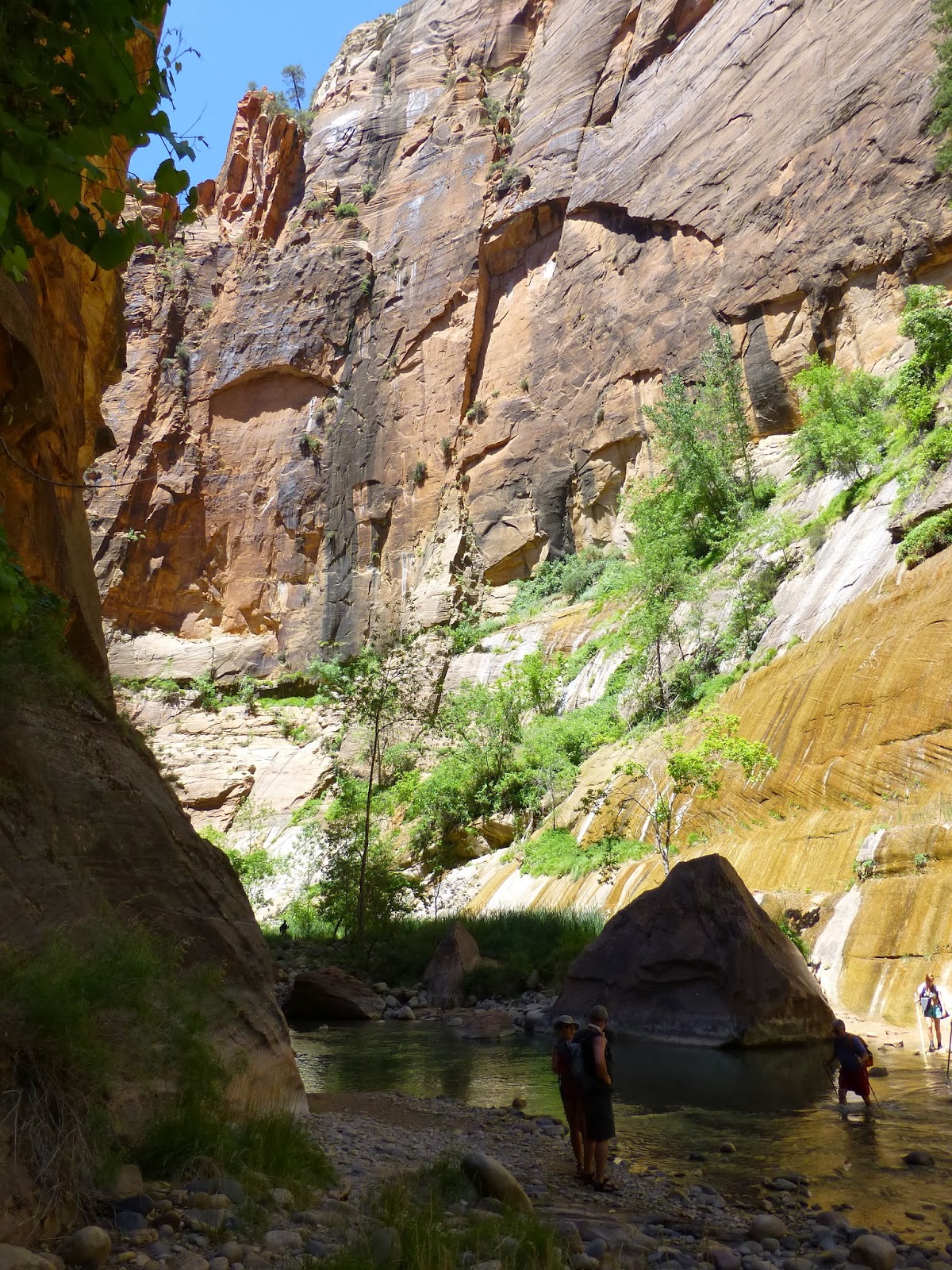
Whichever way you're hiking the narrows, prepare yourself to get wet, which can be a refreshing change in the heat of the summer. The hike requires wading through pools, sometimes up to chest deep (depending on the time of year.) Hiking along the slippery and uneven river bottom is also a necessity, so trekking poles or hiking sticks are helpful. The Narrows shouldn't be attempted by anyone without a wet suit from November through May, due to cold water and high spring flows. 

Do your research, come prepared, and most importantly, have fun exploring one of the most spectacular slot canyons around!


Here are my photos from an August 2012 Narrows trip:


While hiking out of The Narrows and back to the trailhead, we saw a group of people gathering around something on the side of the trail. As we got closer, it became obvious what was drawing the attention. 
The rattlesnake seemed pretty distressed due to all the attention it was drawing, and had backed itself into a corner. Luckily, there was a ranger about a hundred yards down the trail who we notified about the situation. Hopefully she was able to move people along so the snake could go on its way.

I always enjoy wildlife sightings on my trips, rattlesnakes included. I've met some people who despise snakes and would willingly kill rattlesnakes, even if they aren't causing them any imminent danger. This is a mindset that I strongly disagree with. I have encountered several rattlesnakes over the years, and have never felt threatened. Even if you don't like snakes, let's respect these creatures and not be so shocked or outraged when we see them! Remember, we are in their habitat, not the other way around!

The Narrows is a place that most people in decent physical condition can enjoy, and it provides the versatility of a short day hike or a long overnight adventure. Best of all, it provides an escape from the heat of the summer. Don't forget to make The Narrows a part of your next summer trip to Zion! 

Friday, January 10, 2014

Observation Point

It's quite possible that the best day hike in Zion is the trek to Observation Point. At the top, it offers vast, sweeping views of Zion Canyon and beyond. The views are every bit as good as the more popular Angels Landing, but you have to work a little bit harder to get them, with 2100 feet of elevation gained in 4 miles. This hike also doesn't require the same exposure to steep drop-offs that turns some away from Angels Landing, so if you're in good shape but not overly fond of heights, Observation Point might be the better choice. The following description is from my hike in late September of 2011.
The Observation Point trail is accessed at the Weeping Rock trailhead and immediately starts climbing as switchbacks rise into shaded Echo Canyon and its towering, streaked sandstone walls. Echo Canyon itself would be a nice destination for those who don't have the time or ability to continue all the way to Observation Point. Echo Canyon is also one of the only shaded parts of the hike, so it might be a good place to rest before tackling the switchbacks that are soon to follow.

Echo Canyon:


After about 1.5 miles of enjoying Echo Canyon's relatively flat terrain, the trail reaches a junction with the East Rim Trail and access to Cable and Deertrap Mountains (hiking to these areas would best be done as a overnight trip.) Staying left at this junction takes you to Observation Point. This marks about the halfway point of the hike, but the majority of the elevation has yet to be conquered.

The rest of the hike is mostly all uphill with many switchbacks. The last half-mile becomes more gradual as you reach the top of the rim, and make your way towards the views that soon await.

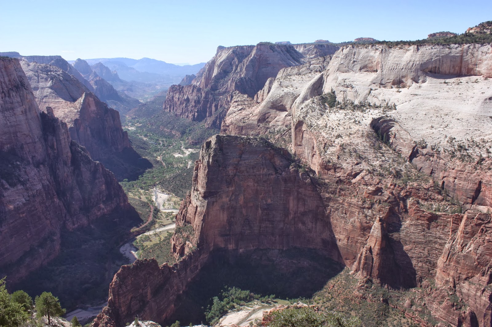
The payoff proves to be well worth the long, uphill trudge. 
Note: The large, fin-like rock formation in the center is Angels Landing.


I rested under the shade of a juniper tree not far from the rim while enjoying my lunch and rehydrating. It was a warm, sunny late September day. I remember thinking how hot it would have been to try this hike two months ago.
I enjoyed the views until I finally made myself turn myself away and start retracing my steps, trying to enjoy the details of my descent.
As I neared the trailhead, I stopped at the trail junction to Hidden Canyon and decided to go check it out. It proved to be a worthwhile and scenic side trip, and one that I'd recommend to anyone who enjoys canyon exploring. Keep in mind, there is some exposure to drop-offs while rising into this canyon.

It was an awesome day of exploring some parts of Zion that I had always wanted to check out. It only took me over 20 years of living in Southern Utah to do it. That's not bad, right?