Monday, May 19, 2014

Mollies Nipple (Grand Staircase)

After bagging a bunch of peaks in Alaska during the summer of 2011, my return to Kanab left me scouting out high points nearby. Although there are no lack of options to explore, the area is much better known for its slickrock and slot canyons than it is for prominent peaks. However, I knew of one that had caught my eye on numerous occasions while driving east of Kanab. The curiosity was too great to not check it out. 

There are several high points in the state of Utah nicknamed "Mollies Nipple" (according to some sources, as many as 11.) Growing up, the one I was most familiar with is near Hurricane, Utah, which I climbed with some friends several years ago (this is also the Mollies Nipple that most closely resembles its name, as far as I've observed.)

Another Mollies Nipple lies about 30 miles northeast of Kanab, and is easily visible in areas along I-80 between Kanab and Page, Arizona. This Mollies Nipple is the most well-recognized landmark on the west side of the Grand Staircase-Escalante National Monument. 

To get there, look for a northbound unsigned dirt road 26.5 miles east of Kanab. At 9.1 miles, you pass through a gate, and at 10 miles, there is a junction, in which you bear right towards Nipple Ranch, Mollies Nipple, and Starlight Ridge. There is another gate immediately beyond this junction. Continue 1.3 miles past this junction where a sandy double track branches right. After about 100 yards there will be a place to park. The last section of this road can be quite sandy and high clearance 4 WD is recommended. 

The sandy double track continues beyond where you park, but it gets progressively sandy and is probably only passable to ATV's. 

After parking, I looked around and noticed Mollies Nipple looming in the distance, seemingly forever away. I knew I'd have my work cut out for me.

                                    I had about four miles ahead of me before reaching the base of Mollies Nipple - not overly daunting in itself, but when you consider the vast majority is across a sandy double track, the trek becomes significantly more draining. 

The track meandered through pinyon and juniper, occasionally coming to crests where views of the peak and beyond were tough to ignore. 


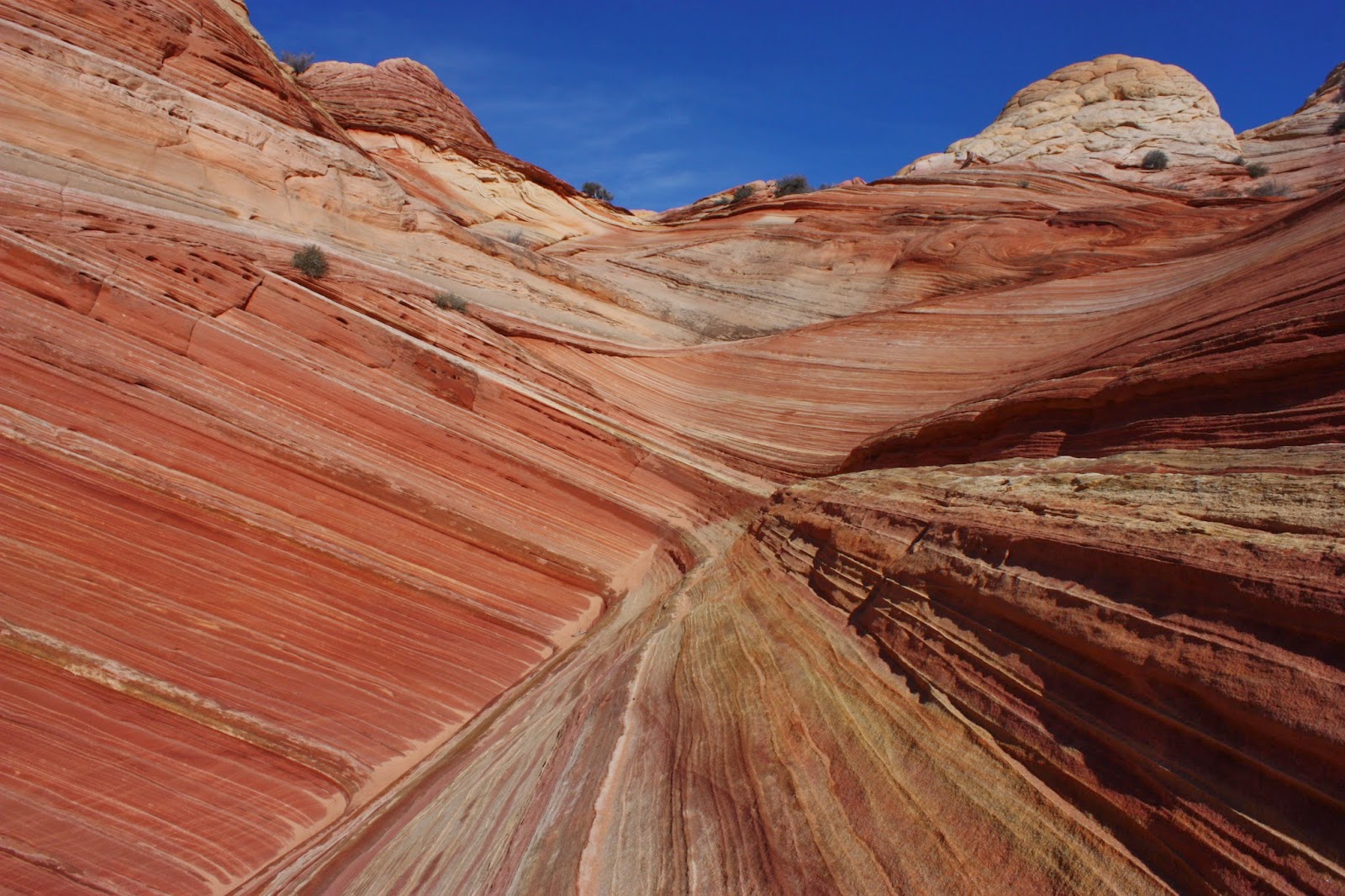
The views were spectacular, and I knew they'd be even better if I was able to ascend the nipple. However, a seed of doubt was planted in my mind as the wind began to pick up. I wasn't sure how sketchy the ascent would be as is...let alone with gusty winds. 

Still, I had a lot of trudging to go before having to worry about that. 

For a while, I tried not looking up at Mollies Nipple, since it didn't seem to be getting closer anytime soon. Maybe if I looked up every 20 minutes, I'd feel like more progress was being made. 

Maybe that theory worked, since before I knew it, Mollies Nipple appeared to be just in front of me. It couldn't be long now!


The closer I got, the less "nipple-like" it appeared. From the angle I was approaching it, it looked more like a fin. 


At this point, it wasn't long before I was directly beneath it. I found a shaded spot at the base to hydrate and refuel before starting the ascent. Despite my rubbery legs from the sandy trek, and the continuing wind gusts, I decided there was no way I would turn back without at least a summit attempt. 700 feet to go (half of the hike's total elevation gain), and straight up...


        I picked a route from the bottom that appeared easiest, and started my ascent. I don't think there was a single rock on the entire slope that was stable, so each step was somewhat of a challenge. The higher I got, the more challenging it became. What began as a hike across loose sandstone soon became a scramble. I considered turning back once, but when I looked down, I told myself that I'd come too far not to continue. 

As I neared the top, I realized that I was past most of the loose stuff, but the steepest part was still to come. I began a hand-over-hand scramble for the last bit. It was a bit nerving, but at least the terrain was more solid. (My guidebook describes the scramble as class 2 and 3 with one class 4 section, although in my opinion it's debatable whether that 4 classification is justified. I, however, am no expert.)

Finally, I hoisted myself up the last section, and was able to see the other side. It wasn't the "true" summit - I was in a saddle between a couple of points that were just a few feet above me. Since I didn't see a safe way of getting to either of them, I was perfectly content with where I was. As for the views...let's just say they didn't disappoint. How could they?


A look down the opposite side from where I ascended:


      I didn't hang out up here for too long, as I only had a small area to stand with quite a steep drop on the opposite side. After soaking in the views one last time, I started my descent. 

Here's a look back towards the top as I started my way down:


Another look up, a while later:


Cool rock formation near the base:


When I finally reached flat ground again, I was simultaneously overcome with a sense of relief and accomplishment. 

Of course, I still had that pesky four-mile sandy hike back to my car. Besides being scared half to death by a cow, it was a relatively stress-free and uneventful return. When back at the car, my legs were thankful!

I was sure to catch one last glimpse of Mollies Nipple near the trailhead, with the sandy double track leading off to the right. 


It was a beautiful November day in the desert, and besides the wind, the weather couldn't have been better. To this day, I look back on my hike up Mollies Nipple as one of my best day hike accomplishments. For anyone looking for a true challenge to mix things up in canyon country, I highly recommend checking out Mollies Nipple.

Wednesday, March 26, 2014

Doin' The Wave

By far, the most popular and recognizable area within the Vermillion Cliffs National Monument and its surrounding areas is a place simply known as "The Wave." The first time you see photos of this area, it's immediately obvious why people travel from across the world to visit the incredible geologic formations of red, white, and yellow swirling slickrock. 

However, visiting The Wave is not done easily. Due to its popularity, and the fragile nature of the sandstone (which visitors hike directly upon) the Bureau of Land Management requires visitors to obtain permits in advance. 20 permits are issued for each day - 10 of these are issued online several weeks in advance, and the other 10 are set aside as "walk-in" permits issued the day before your desired trip. All of the permits are issued based on a lottery system, rather than "first come, first serve," so obtaining a permit is simply the luck of the draw. For more information, refer to the BLM's website HERE.


To give you an idea of the likelihood of obtaining a Wave permit, especially if your dates aren't flexible: it took me 4 or 5 attempts to obtain a walk-in permit before I finally succeeded, and these attempts were all during the "slow" season. During the summer months, your odds decrease significantly. Luckily for me, I lived in Kanab (where they do the walk-in lottery) so I didn't have a high sense of urgency to obtain a permit during a specific day.

For those who are unable to obtain a Wave permits: DO NOT BE DISCOURAGED! The Wave is just one of many options you have to explore in the area. Don't let its popularity fool you, there is other stuff that is just as good, if not better than The Wave. Ask a ranger in the Kanab BLM visitor center and they'll be more than happy to direct you to a viable alternative to The Wave.

One more important point I'd like to make before describing my hike to The Wave - for those lucky enough to obtain a permit: This is not your "average" 5.5 mile hike. Most of the hike is off trail, with little to no shade. The BLM will hand out a trail guide with pictures of landmarks to help guide you along the way. Make sure you bring this on your hike. Without it, even the most advanced hikers could lose their way, especially if it's their first time to The Wave. Bring plenty of water, especially in the summer - more than you think you'll need. Most importantly, don't do anything that you feel is beyond your comfort/ability level. Normally, I'm not one to try and scare people away, but last July (2013) alone, 3 hikers died while attempting The Wave, and all cases were completely avoidable had they been better prepared, and had a better idea of their abilities.

Thanks for listening to my shpeel. Now, on to the fun stuff!

I was pretty excited when I finally scored a Wave permit, especially after one of my failed attempts when the odds were considerably in my favor (14 people for 10 permits) and Stephany and I were 2 of the 4 left out. Ouch.

The Wave shares a trailhead with Wire Pass up the House Rock Valley Road, but the trail splits out of the wash, where there is an obvious sign. Make sure you have a permit!
For a while, there is an obvious trail, but soon, you begin hiking across slickrock with no trail or rock cairns to guide you. I can't over-empasize how helpful the BLM's handout is in helping you find your way. 

We chose a sunny but chilly December day (in 2011) to complete the hike. Overall, the hiking weather was perfect, and it's nice not having to worry about the blistering summer heat. If at all possible, I highly recommend hiking The Wave during the "slow season."

Despite all of my warnings about preparing to hike The Wave, if you're an advanced hiker, chances are you won't find the hike to be overly difficult. It's truly amongst the most fascinating marvels that nature has to offer. 

During my hike, I didn't take many photos along the way, but once I arrived at The Wave, I had a tough time putting my camera down. 


Warning: tons of pics to follow!


(Yes, dogs are allowed at The Wave!)


Doing The Wave Dance!


(Actually, it's my dance for all things awesome.)


We scrambled up to a high point to catch some views of the surrounding area.


Obviously, a trip to The Wave is about way more than The Wave itself.

Back to the streaky stuff!


Perhaps my personal favorite:


Wave Cave (or cavern, or whatever...)


Making our way back:


Sorry if that photo overload was a bit excessive, but I think it was necessary!

Continuing back to the trailhead left us with a feeling of complete satisfaction. One day I hope to return to The Wave but if I don't, it's okay, because I know I'll never forget it. 

If you are fortunate enough to get a Wave permit, I am sure you will be thoroughly satisfied with your experience, as I was. If you are unable to obtain one: I can almost guarantee that you will also be thoroughly satisfied by one of the countless other options the area has to offer.

Wednesday, March 12, 2014

Wire Pass and Buckskin Gulch

Within the Vermillion Cliffs Wilderness area lies Paria Canyon and its tributaries. One of its main tributaries is Buckskin Gulch, which is arguably the longest slot canyon in the world at 21 miles, and is certainly one of the most impressive.

There are several different ways to approach Buckskin Gulch, and can be done as a backpacking trip with a one-way shuttle. If interested in doing Buckskin Gulch as a backpacking trip, you can find more information HERE.

As a day hike, the most popular route starts at the Wire Pass trailhead, where there is an obvious parking area 8 miles up the House Rock Valley Road, south of highway 89 (between Kanab, Utah and Page, Arizona.) This dirt road is usually in decent shape, but may be impassable when wet.

At first, the hike starts up a wash and is pretty uneventful, but know that it gets much, much better!

Soon, you enter Wire Pass, a tributary of Buckskin Gulch and an impressive slot in its own right. I have taken two trips into Buckskin Gulch via Wire Pass. Here are the highlights.

Stephany, who had just moved to Kanab from Connecticut a couple of months prior:
(Apparently, they don't have slot canyons like this back east.)


After about 1.7 miles, Wire Pass joins Buckskin Gulch, where the canyon opens up in spectacular fashion, with towering, streaked rock walls all around. 

Here's a photo at the confluence, looking back towards Wire Pass:


For scale:
Once reaching Buckskin Gulch you can either take a left and head back towards the House Rock Valley, or a right, and wander for miles. Buckskin Gulch's canyon walls are much higher than Wire Pass, but not as narrow in most sections. I definitely recommend hiking to Buckskin via Wire Pass rather than starting on Buckskin from the beginning. Wire Pass offers a slightly different, more "intimate" slot canyon experience.

Here's a look into Buckskin Gulch (right of the confluence from Wire Pass):
Working our way back through Wire Pass, which sometimes opens up with views of colorful slickrock:


On a different trip, I took my friend Shenon on the same hike while he visited me in Kanab. This time, I elected to go left at the confluence. We discovered some interesting mud slabs that we entertained ourselves with. 


Soon, we reached an area where the canyon opened up, and we were able to hike up the slickrock and explore the area a bit more. 

In some areas, the rock formations resemble the nearby Wave.


After a while, we decided to sit back, relax, and soak in the views.


On our way back through Buckskin Gulch, we spotted a Gopher Snake. Surprising, considering it was a chilly November day. 
Wire Pass and Buckskin Gulch are spectacular, easily accessible slot canyons that offer the versatility of short day hikes or longer, overnight adventures. Nearby, there are countless other attractions that are also worth exploring. As I recollect these trips, it makes me miss slot canyon and slickrock country. Trust me, if you get the chance, you don't want to miss out on exploring these amazing places!