I have highlighted some of my most epic and memorable adventures from Mount Rainier in the posts that I have made. However, there are many more areas of Rainier that I explored, some of these were with great friends that I wouldn't feel right leaving out of my blog. In this final Mount Rainier entry, I'll combine the rest of these adventures.
___________________________________________________________________Eagle Peak
One of the first hikes that I attempted during the summer was Eagle Peak, which is accessed near the Longmire community where I lived. Eagle Peak is the westernmost peak of the Tatoosh range, a rugged mountain range located near the Park's southern boundary.

It was June when I decided to try a solo hike to the top, which was a time that many areas of the Park were still snow covered. I wasn't expecting the Eagle Peak trail to be any different as I ascended towards the top. Still, I decided to see how far I could make it.
Along the way, I ended up running into some friends that had also decided to attempt Eagle Peak. Perfect. Company is always welcome.
I hiked with the group, and as expected, we ran into snow as we ascended the trail. Luckily, we could still find our way and made it all the way to the "saddle", where the trail ended.
During the summer, it is possible to hike to the very top of Eagle Peak, which leaves the trail. However, the snow and icy conditions at the top would make that a dangerous attempt this early in the year.
It was a gorgeous day to be out for a hike, and I was happy to meet up with some friends.
Here are some pics:


___________________________________________________________________
Grove of the Patriarchs & Silver Falls
Two of the most popular "short" hikes at Rainier are located in the southeast, low elevation areas of the Park, near an area called Ohanapecosh. These are the trails to Grove of the Patriarchs and Silver Falls.
 Neither of these hikes provide amazing views, nor do they wind through wildflower meadows like some of the "classic" Rainier hikes. Instead, these trails take you through old growth forest, with the ending point of Grove of the Patriarchs being two ancient Douglas fir trees and a massive western red cedar. Silver Falls (as you might assume) takes you to an impressive waterfall. These are excellent, laid back strolls with little elevation change, and great if you want to see a slightly "different" side of Rainier without overly exerting yourself.
Another point of interest on the Grove of the Patriarchs trail is a suspension bridge that crosses a crystal clear, pebbly river.
 Here I am, in front of the two 1000-year-old Douglas fir trees on Grove of the Patriarchs trail:
Another look at the same trees (notice the top of the tree on the right is gone. It could have snapped off in a wind storm or lightning strike hundreds of years ago, yet the tree is still alive.)


Looking towards the top of the tree:

Another huge cedar tree nearby:

There are a few different ways to access Silver Falls, but if you're at already at Grove of the Patriarchs, you might as well take the trail that starts directly across the street (see map).
Starting from that access point, this hike is a little longer, but still short and fairly easy overall.
I'll let the pictures do the storytelling.


___________________________________________________________________
Pinnacle Peak
One day, I got home from work and didn't feel like settling in and grabbing a beer (which was the usual post-work repertoire). Instead, I was feeling a bit adventurous. Summers in the Pacific Northwest provide long daylight hours, and I decided that this would be a good day to take advantage of that.
Pinnacle Peak is the second highest peak in the Tatoosh Range (with a name like "Pinnacle," you'd think it would be the highest, but it's just shy of nearby Unicorn Peak). The Pinnacle Peak trail is moderately strenuous by most standards because of elevation gain, although fairly short. This is one of those "classic" day hikes that I wouldn't have felt right leaving Rainier having never completed.
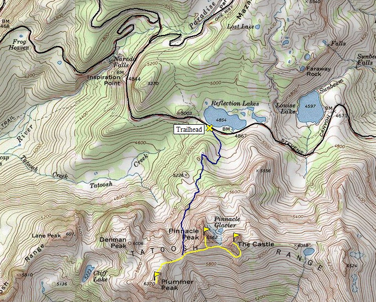
The Pinnacle Peak trailhead is located directly across the Stevens Canyon Road from the famous Reflection Lakes. When I arrived, I immediately started hiking briskly to combat the waning daylight hours.
From the ridgetop, views of Rainier to the north were excellent:

Looking to south, it was hazy, but Mount Adams was also clearly visible.

After enjoying the sunset and exploring the ridge, it was time to head back. I brought my headlamp, but I still didn't want to be hiking down the fairly steep, uneven trail in complete darkness.
As I started back, I ran into this huge, beetle-like insect on the trail:

It turned out that I probably stuck around the ridgetop longer than I should have. I wasn't even halfway back to the trailhead before digging my headlamp out of my backpack. I like night hiking, but I prefer it when I have company. At one point, I saw a set of eyes glowing back at me as I aimed my headlamp in the creature's direction. At first, I couldn't make out the shape of its body in the darkness. This was black bear and mountain lion country, and although I'm not normally afraid of either, seeing one that close while alone in the darkness was an eerie thought. I was frozen in my tracks for a few seconds, before I could finally make out the shape of a deer's head. I yelled out, and it took off into the woods. That got my heart pounding.
I continued back to the trailhead and arrived at my car without further incident. It was a good evening hike, and another one that I was happy to cross off my list.
___________________________________________________________________
One Last AdventureI ended up sticking around Rainier about as long as I possibly could after my job was over. I just didn't want to leave! Could you blame me?
After moving out of Longmire, my friend, Emily, who lived in Tahoma Woods (another government housing community just outside of the Park) invited me to stay in her apartment for my last few days in Washington. She had an open room, and I had a hard time turning down the offer.
One of my very last days in Washington, I was up for one last adventure. Nothing crazy, just something new.
After scouting out my map, I decided that I'd check out a hike that starts just outside of the park in the Glacier View Wilderness, which is part of the Gifford Pinchot National Forest.
I took the fairly rough Forest Service road 059 to the even rougher 5920. These roads had lots of ruts and probably wouldn't be accessible in a low clearance vehicle.
I never got a full view of Rainier because of the mid-level clouds, but seeing the base and the top of the mountain was good enough for me. The clouds just added an extra cool effect.

 A zoomed-in look at the Tahoma Glacier:
A look at Gobbler's Knob lookout (the place I had planned on hiking to).
 The views in the direction of Rainier were probably better than anywhere else due to low clouds. Still, those clouds provided some pretty cool wisping displays.
 Here's some of those cotton candy-like clouds:


They were mesmerizing. I stayed on that rock for a long time, watching the clouds and enjoying some of the final views of Rainier that I would get all summer.
When I was finally ready, I got up and started retracing my steps. The trail continued north but I had some last minute errands to run before heading home.
On the way back, I discovered a large wild blueberry patch, which I took full advantage of. I gorged myself with ripe berries for 20 minutes. I felt like a bear by the time I was done.
Although it didn't take me to where I had planned, it was an awesome adventure to end the summer. I was feeling bummed out that it was all coming to an end, but I knew that I'd be back. There is no way I'd let myself stay away after the summer that I just had.
Here's a great big thank you for everyone that contributed to one of the best summers of my life!
Oh man. I didn't even remember doing that hike with Russ. Oh Russ...
ReplyDelete